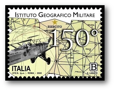
The Military Geographical Institute turned 150 this year. To commemorate this event, a stamp was issued in which the very detailed maps of the Institute are depicted in the background and in the foreground a plane from the 1930s intended for photogrammetric surveys.
The origin of today’s Institute is parallel and consequent to the birth of the Kingdom of Italy (1861) and can be traced back to the Office of the Corps of Major state of then Italian army (the denomination of “Royal Army” dates back to 1879) which, after the Italian unification, had unified into a single structure, with headquarters in Turin, the functions and experiences of the original General Staff Office of the Sardinian kingdom, of the Tuscan Topographical Office and of the Royal Neapolitan Topographical Office. The headquarters of the office was then moved to Florence in the1865, at the same time as the appointment of the Tuscan city as the capital of Italy, a city that is still today the headquarters of the Institute. With the unification of Italy, the need was recognized for the State to equip itself with a unitary national cartography, and theGovernmentof the time entrusted in the 1872, with a special law, this task to the specially created Military Topographical Institute. This institute, renamed the Military Geographical Institute in 1882, took over the territory of the State, forming the new Topographic Map of Italy on a scale of 1:100,000. This topographical work took over 30 years.
Today the Institute is an institution of the Army which depends on the Military Command of the capital; its job is to produce terrestrial cartography. It is one of the technological and scientific jewels of our country: a structure that produces and updates the official cartography of the national territory, the geographical data, the updating and maintenance of the geodetic networks, the periodic aerial photogrammetric coverage of the national territory and many others public utilities, civil and military.
In its staff there is also a school called Higher School of Geographical Sciences (SSSG). It is based inFlorence on the way Cesare Battisti and occupies a large part of the former Monastery of the Santissima Annunziata.